Cuxpedia sucht Bilder aus Ihrem Fotoalbum. Sie kûÑnnen uns helfen. Mehr...
Datei:Quarantaene Karte.jpg: Unterschied zwischen den Versionen
Aus cuxpedia
Admin (Diskussion | BeitrûÊge) K |
|||
| Zeile 1: | Zeile 1: | ||
| + | ==Motiv== | ||
| + | Karte 1:25.000 Cuxhaven | ||
| + | ==Quelle== | ||
| + | http://contentdm.lib.byu.edu/cdm/singleitem/collection/GermanyMaps/id/1865/rec/1 | ||
| + | |||
| + | :Creator Germany. Reichsamt fur Landesaufnahme | ||
| + | :Title Cuxhaven | ||
| + | :Sheet Number 2118 | ||
| + | :Edition Electronic reproduction | ||
| + | :Publisher Digital Bigham Young University | ||
| + | :Scale 1:25,000 | ||
| + | :Owning Institution Brigham Young University | ||
| + | :Genre Maps | ||
| + | :Subject Germany--Maps, Topographic | ||
| + | :Type Image | ||
| + | :Format image/jp2 | ||
| + | :SIRSI ID DFS2778 | ||
| + | :Series GSGS (Series) 4414 | ||
| + | :Standard Map Series Designation M841 | ||
| + | :Call Number 2118_G6080_s25_G4 | ||
| + | :File Name 2118_G6080_s25_G4.tif | ||
| + | :Coverage northlimit=53.902578 eastlimit=8.881954 southlimit=53.791856 westlimit = 8.651649 | ||
| + | :KML file http://www.lib.byu.edu/cdm-maps/german-maps/kml/2118_G6080_s25_G4.kml | ||
| + | :TFW file http://www.lib.byu.edu/cdm-maps/german-maps/tfw/2118_G6080_s25_G4.tfwx | ||
| + | :Patron Usage Instructions http://www.lib.byu.edu/generic_copyright.html | ||
| + | :Copyright Status/Owner Public Domain, Courtesy Harold B. Lee Library, Brigham Young University | ||
| + | |||
| + | |||
| + | {{Vorlage:Bild-PD}} | ||
Aktuelle Version vom 25. Dezember 2012, 21:38 Uhr
Motiv
Karte 1:25.000 Cuxhaven
Quelle
http://contentdm.lib.byu.edu/cdm/singleitem/collection/GermanyMaps/id/1865/rec/1
- Creator Germany. Reichsamt fur Landesaufnahme
- Title Cuxhaven
- Sheet Number 2118
- Edition Electronic reproduction
- Publisher Digital Bigham Young University
- Scale 1:25,000
- Owning Institution Brigham Young University
- Genre Maps
- Subject Germany--Maps, Topographic
- Type Image
- Format image/jp2
- SIRSI ID DFS2778
- Series GSGS (Series) 4414
- Standard Map Series Designation M841
- Call Number 2118_G6080_s25_G4
- File Name 2118_G6080_s25_G4.tif
- Coverage northlimit=53.902578 eastlimit=8.881954 southlimit=53.791856 westlimit = 8.651649
- KML file http://www.lib.byu.edu/cdm-maps/german-maps/kml/2118_G6080_s25_G4.kml
- TFW file http://www.lib.byu.edu/cdm-maps/german-maps/tfw/2118_G6080_s25_G4.tfwx
- Patron Usage Instructions http://www.lib.byu.edu/generic_copyright.html
- Copyright Status/Owner Public Domain, Courtesy Harold B. Lee Library, Brigham Young University
 |
|
Dateiversionen
Klicke auf einen Zeitpunkt, um diese Version zu laden.
| Version vom | Vorschaubild | Maûe | Benutzer | Kommentar | |
|---|---|---|---|---|---|
| aktuell | 13:06, 23. Dez. 2012 | 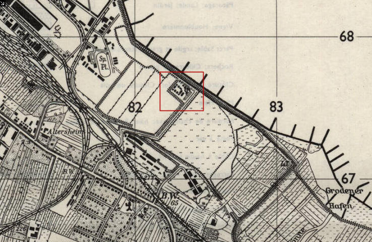 | 738 û 482 (105 KB) | Hartmut Mester (Diskussion | BeitrûÊge) |
- Du kannst diese Datei nicht û¥berschreiben.
Dateiverwendung
Die folgende Seite verwendet diese Datei: